Field Reconnaissance: 20
November 2004
Reconnaissance of
Possible Fault-related Surface Deformation
Keith Kelson,
Ellen Rathje, and Yuki Yamakawa
GEER Beyond
Reconnaissance Team
The reconnaissance
team investigated the possibility of fault-related surface deformation (e.g.,
surface fault rupture, surface folding) along faults previously mapped near the
up-dip projection of the rupture plane.
To estimate the surface location of possible causative faults, we used
data from http://iisee.kenken.go.jp/staff/yagi/eq/20041023/Japan20041023-j.html,
which suggests the rupture plane had southeast-vergent
reverse fault movement and projects toward the ground surface along the western
margin of the Aburuma
River valley in the
vicinity of the towns of Koide and Hirokami. Based on an existing 1:25,000-scale map of
active faults in this area published by the Japan Geographical Survey
Institute, this valley margin is bordered by the Obiro
and Western Muikamachi Basin faults (Figure 1). These faults exhibit evidence of late
Quaternary surface deformation in the form of faulted and folded river
terraces. The faults have
up-on-the-northwest displacement, which is consistent with the southeast-vergent sense of reverse movement during the
earthquake. In map view, these two
faults form a left-stepping en echelon pattern, with an active syncline present
between the southwestern end of the Obiro fault and
the northeastern end of the Western
Muikamachi Basin fault.
No
prominent evidence of surface deformation was observed during our
reconnaissance along the Obiro or Western Muikamachi
Basin faults (Figure 1). Several cultural features (e.g., roads,
curbs, retaining walls) are present across traces of this fault system that
enable an assessment of the presence or absence of fault-related surface
deformation. Along the Obiro fault, there was no prominent evidence of
fault-related surface cracking or other forms of deformation where the fault
crosses Roads 291 and 558, as well as smaller roads in between (Figures 2 and 3). Similarly, there was no prominent evidence of
surface deformation across the Western
Muikamachi Basin fault where it crosses Roads 291
and 558, and several other smaller paved roads west of Road 230 (Figures 4, 5
and 6). We also observed no surface
deformation along the mapped fault trace through the city of Koide.
Nevertheless, our reconnaissance was not a comprehensive assessment
along the entire length of either of these faults, or of other faults that may
have experienced possible surface deformation during the earthquake.
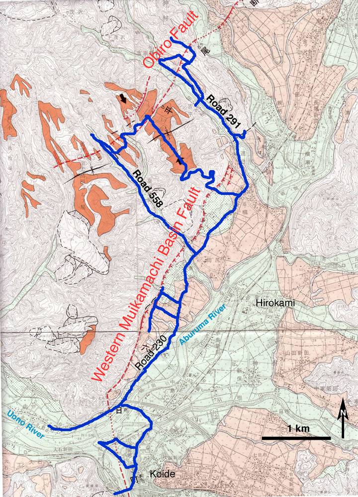
Fig. 1.
Map of active faults in the Koide-Hirokami area,
showing reconnaissance route taken to assess possibility of surface
deformation.
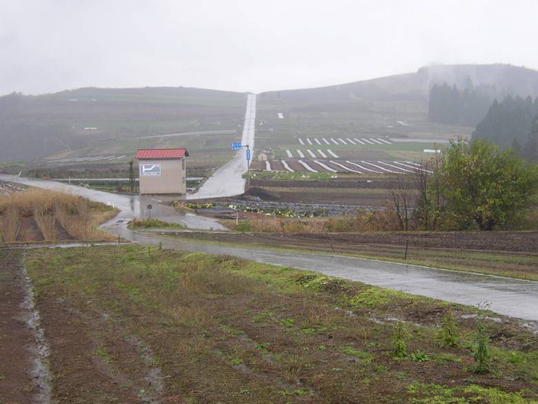
Fig. 2. View to
southeast across the Obiro fault and a broad late
Quaternary syncline developed on alluvial deposits above the upper Aburuma
River valley, near Hironouchi. Syncline
is developed between the Obiro and Western
Muikamachi faults. No prominent evidence of surface deformation
was present across the Obiro fault where it traverses
the paved roadway on the near side of building in center of photograph
(37.281˚N, 138.960˚E; photo PB200388 by K. Kelson,
November 20, 2004).
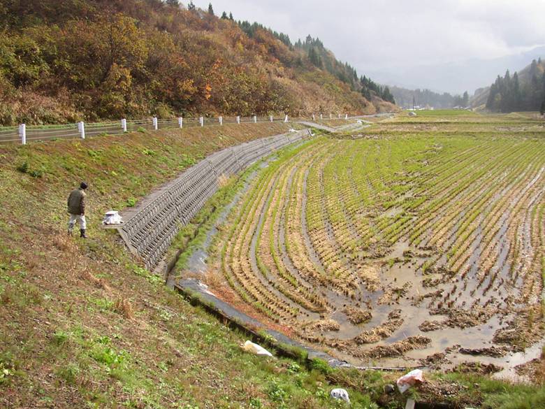
Fig. 3.
View to southeast across the Obiro fault trace and
down a moderate-sized alluviated tributary valley
near Hironouchi.
No prominent evidence of surface deformation was present across the
mapped fault trace where it traverses the paved roadway or the brittle
retaining walls bordering the valley floor. White instrument on retaining wall
near Dr. Y. Yamakawa is one of several seismometers
installed across the fault trace by Nagoya
University (37.278˚N,
138.952˚E; photo PB200389 by K. Kelson, November
20, 2004).
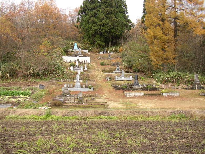
Fig. 4. Southeast-facing fault scarp along the Western Muikamachi
Basin fault, occupied by a
collection of cemetery monuments.
No evidence of surface deformation was present along this fault scarp,
although several monuments toppled (37.279˚N, 138.976˚E; photo
PB200371 by K. Kelson, November 20, 2004).
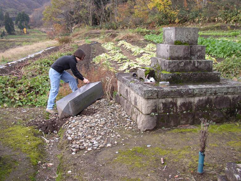
Fig. 5. View to
southwest along southeast-facing fault scarp marking the Western Muikamachi
Basin fault (as shown in Fig. 4). No evidence of surface deformation was
present along this fault scarp, although several monuments toppled
(37.279˚N, 138.976˚E; photo PB200380 by K. Kelson,
November 20, 2004).
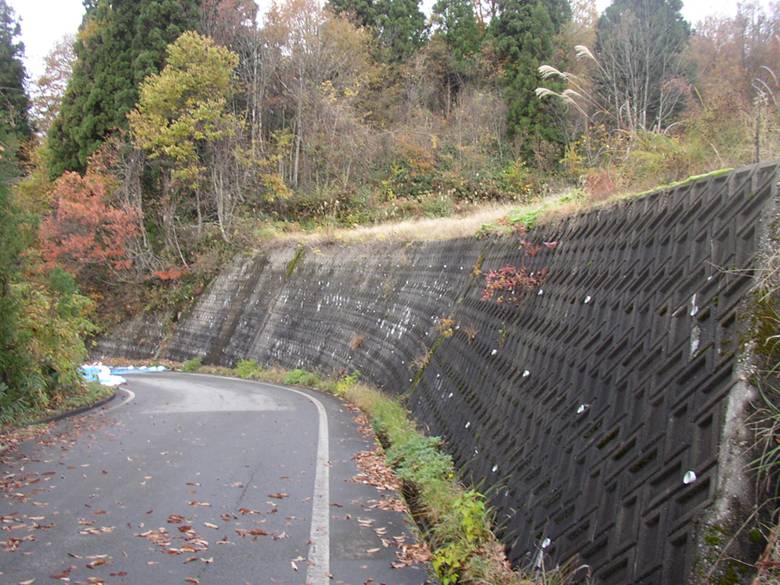
Fig. 6. View to
northwest along retaining wall crossing the Western Muikamachi
Basin fault, near Highway
291. No evidence of faulting or fold
deformation was present along this retaining wall or paved roadway across
mapped fault trace (37.279˚N, 138.976˚E; photo PB200381 by K. Kelson, November 20, 2004).